What happened that day?

Map of Wellington College students killed in Belgium

Map of Wellington College students killed in Belgium

The impact of the First World War on local communities and institutions such as clubs and schools is starkly illustrated by the experience of Wellington College. During the war 1643 of this school’s former pupils served overseas. Of these, 222 were killed, and a further 350 were wounded.

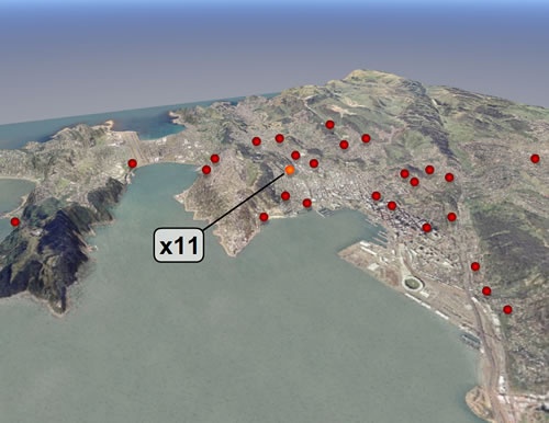
This map of Wellington shows the location of the homes of some of the 40 college old boys who were killed on the battlefields of Belgium (including 11 who had been boarders at the college). In a pattern repeated throughout New Zealand, few streets or suburbs were untouched by the fatal consequences of war. Many residents would have known or been related to one or more of these men.

Ministry for Culture and Heritage

How to cite this page: 'Map of Wellington College students killed in Belgium', URL: http://www.nzhistory.net.nz/media/images/wellington-college-map, (Ministry for Culture and Heritage), updated 4-Oct-2007

Community contributions


There are currently no community contributions for this page - please fill out the form to the right if you would like to add your story

What do you know?

Can tell us more about the information on this page?
Perhaps you have a related experience you would like to share?

The content of this field is kept private and will not be shown publicly.
CAPTCHA
This question is for testing whether you are a human visitor and to prevent automated spam submissions.

Comments will be reviewed prior to posting. Not all comments posted. Tell me more...