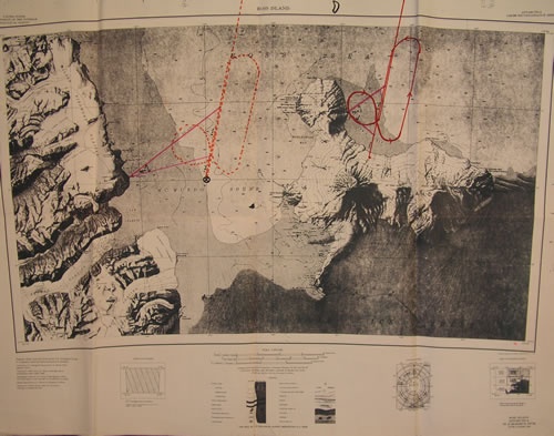
This map shows the actual flight path of Air New Zealand Flight TE901 on 28 November 1979 (solid red line) before it crashed on the lower slopes of Mt Erebus. The dashed line at left shows the flight path the crew probably thought they were on.
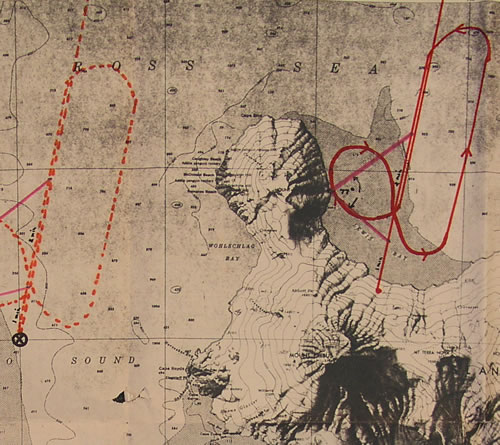
In the detailed image Mt Erebus is in the foreground.
The navigational coordinates
Fourteen months before the Erebus disaster, when Air New Zealand's routes were being computerised, a typing error altered one of the navigational coordinates for the Antarctic flights. This moved the destination point some 27 nautical miles to the west. Instead of the instrument flight rules (IFR) route taking aircraft over Mt Erebus en route to McMurdo Station, it would take them over sea ice west of the Dailey Islands.
Changing coordinates
In the period the Antarctic flights operated, the position of the destination point changed three times:
- 1977/78 - 166.48 east - seven flights were routed over Mt Erebus to McMurdo Station
- 1978/79 - 164.48 east - seven flights over sea ice, en route to the west of the Dailey Islands
- 28 November 1979 - 166.58 east - Flight TE901 was routed over Mt Erebus to McMurdo Station
A number of flight crews in 1978/79 noticed the discrepancy in the destination point, but it was first reported to Air New Zealand by Captain Simpson following his Antarctic flight on 14 November 1979. Simpson, who had attended the same route qualification briefing as the crew of Flight TE901, noted that there was a considerable distance between the destination point he had programmed from the flight plan (west of the Dailey Islands) and the actual position of the McMurdo Tactical Air Navigation system and McMurdo Station (the destination he had been briefed on). On his return Simpson told Captain Johnson of the airline's flight operations section, who asked the navigation section to investigate.
The navigation section checked the coordinates on a computer printout of what they believed was the current flight plan, but was actually the original that had not been used for 14 months. Their examination inevitably revealed no major discrepancy, but they did note that a minor adjustment had been made to the position of McMurdo Station and decided to change the coordinates accordingly. They believed they had made an adjustment of 2.1 nautical miles to the longstanding destination point, but when translated into the current flight plan it was actually an adjustment of 27 nautical miles to the east. Instead of the IFR route taking TE901 over flat sea ice, as members of the flight crew had been briefed, it would take them over Mt Erebus, a 3794-metre active volcano.
The adjustment was made in the airline's ground computer at 1.40 a.m. on 28 November 1979. Later that morning the flight crew of Flight TE901 were handed the adjusted 'correct' flight plan. However, they were not alerted to the adjustment either before or during their pre-flight briefing. After the briefing the crew undertook pre-flight checks which included manually entering the coordinates from the flight plan into the on-board computer and double-checking that they were correct.
Part of: Timeline to disaster
Next page: The flight
Further information
- The Erebus flight path controversy (NZALPA's Erebus website)
Community contributions