At 12.40 p.m. on 13 November 1896, Te Maari, a crater situated at the north end of the Tongariro range, erupted spectacularly. It continued to erupt at various intervals for nearly a year.
An earlier eruption in the range had formed the crater in 1868, named for a Māori chieftainess who died around that time. It may have first erupted in November 1892 – when it reportedly ejected water, sand, small stones and pumice. Other outlets in the Tongariro range also showed activity during this period, including Ngāuruhoe, Tongariro’s main active vent.
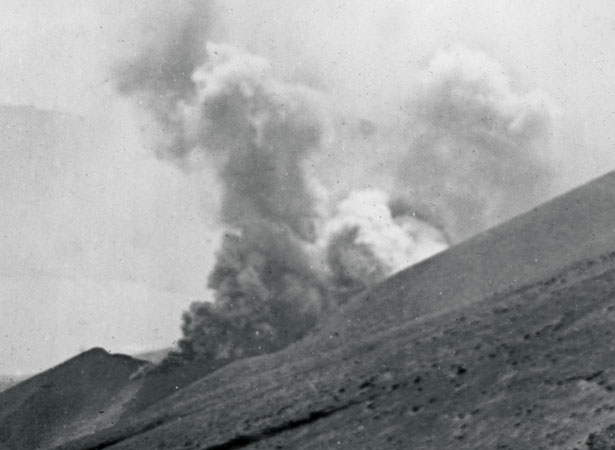
Te Maari’s first 1896 eruption reportedly turned the ‘small steam vent’ into a ‘large crater’ measuring 100 m in length and 150 m in breadth. It lasted for about 40 minutes, emitting steam and smoke to a great height. Fine weather allowed onlookers to see the plume from some distance away. The wind carried a cloud of red ash towards Ātiamuri north of Taupō. A party on the slope of the Tongariro mountain at the time made a hasty retreat. Residents from Otukou, a Māori settlement situated immediately beneath the crater, also evacuated the area. The crater erupted again at 3 p.m. but this time the eruption was obscured by smoke.
The crater continued to erupt at various intervals until October 1897. A party that visited the site in January 1897 noted the damage the eruptions to date had caused:
The scene now, on the mountains, in the vicinity of the crater, is one of great desolation, and in fact the whole of the Tongariro range is bespattered with mud and stones. Large stones weighing four or five tons have been ejected in a southerly direction on to the top of the mountain, which is half a mile distant and 600 feet higher. Where the top of the mountain is flat these stones have become embedded in the earth with the force of their descent. The stones are mostly of a dull red and yellow and have the appearance of having been recently hot. No lava came from the crater, but a stream of mud and rocks has flowed down the mountain side, cutting a path through the bush, across Waimarino Road, and into Lake Roto-aira.
Again other outlets in the range, including Ngāuruhoe, also showed activity during this period. Ngāuruhoe continued to experience frequent ash eruptions, as well as significant lava eruptions in 1870, 1948–49, 1954 and 1973–75. The Te Maari crater remained quiet until 6 August 2012 when eruptions of ash and rock caused disruption to road and air traffic particularly on the East Coast of the North Island.
All these earthquakes pale in comparison to the 200 AD Taupō eruption, the pyroclastic flows from which would have incinerated everything within an area of 20,000 square km. The Chinese and Romans chronicled its effect on the atmosphere.
Image: Eruption of Mount Tongariro, Hawera & Normanby Star, 16 November 1896 (PapersPast)
Community contributions